60 |
Oilfield Technology
June
2016
Oceannumerical simulation
As rigorous statistical analysis requires as long of a time series
as possible to estimate reliable averages and extreme values of
metocean conditions, ocean numerical simulations are solutions of
great interest to complete the in-situ and remote measurements.
Ocean current or wave numerical simulations are produced
using wave or ocean current numerical models.
A numerical model is a computer program that solves the
equations of ocean dynamics, like the Navier Stokes equation for
ocean currents for instance. These computer programs have been
developed by oceanography research centres since the 1970s.
These programs have greatly evolved over time, considering more
complex and more detailed oceanic phenomena. The setup of an
ocean current model goes through several key steps.
The first step requires the definition of a spatial grid over a
limited area covering an ocean or a sea. At grid crossings, called
‘nodes’, the numerical model will solve the relevant equations
taking in account the water depth, the wind forcing, and the
information from surrounding nodes. The resulting solution
of the equations provides the ocean current magnitude and
direction, for an ocean current model for instance.
As the model solves the equation at each node, a map can be
obtained with values of ocean current speed and direction at each
node. The different forcings and boundary conditions applied
corresponding to a specific date and time, the model provides a
view of the ocean currents over the chosen area for a specific date
and time. The numerical model then repeats that operation for
several dates and times, reproducing the ocean conditions over a
chosen time period, which can be as long as forcing and boundary
condition information are available, thus producing a ‘hindcast’.
As the equations of ocean dynamics are non linear, numerical
modelling programs discount the equations, make approximations,
and include different hypotheses to solve them. These different
choices necessarily generate additional unrealistic ‘numerical’
variability that makes the model deviate from the real conditions.
Hence, numerical simulations need to be calibrated then
validated with in-situ or remote measurements as much as
possible. Numerical models do not
replace measurements but are very
efficient at covering more spatial
and temporal ground, thus giving
more confidence in the statistics
computation, especially the extreme
value computation.
So when looking for metocean
data in a new area of exploration,
relevant numerical simulation datasets
provide the first knowledge of the
historical metocean conditions. This
information will then be completed and
improved with the setting up of in-situ
instruments.
Thechallengeof ‘bigdata’
Ocean numerical solutions are thus a
great solution but they also represent a
large amount of data, which is difficult
to fully analyse efficiently to get the
most out of. There are a large number
of in-situ measurements and existing ocean numerical simulation
datasets covering the whole ocean but taking advantage of this
available information when they represent Terabytes of data is
a real challenge. So as oil and gas offshore exploration keeps
expanding, numerical simulation will be used more and more to
understand offshore conditions. It is then important that tools to
access and analyse these large amounts of data become easily
accessible to in order to remove one key challenge from the long
process of exploration.
The big data management and analysis, ‘big data mining’,
implies dealing with large storage, fast data access, fast
extraction and analysis.
Open Ocean spent three years working on these issues to
optimise big data mining, the time for statistical computation,
the statistical methodology robustness and the ergonomics of an
interface to make it accessible to experts and non experts.
With this goal in mind, Open Ocean has developed
Metocean Analytics combining years of experience in
oceanography and metocean analysis for the offshore energy
sector, with state of the art web technologies.
Management of big data first requires the organisation of the
data in such a way that it can be quickly and efficiently searched.
The Netcdf format commonly used for numerical simulation
output is a solution of choice because of the associated metadata
that allows it to target directly only the required time series for a
given longitude and latitude.
In order to compute more than one hundred statistics on
wind, wave and ocean current data in just a few minutes, it is also
necessary to optimise the statistics computation process. The
statistical toolbox code is thus parallelised to be run on several
processors at the same time.
By combining a large catalogue of numerical simulation data,
with fast computing statistical tools and a report editing tool,
Metocean Analytics is a solution designed to take full advantage
of all the latest advancements in big data management and
mining, removing most of the hassle of finding and analysing
metocean data.
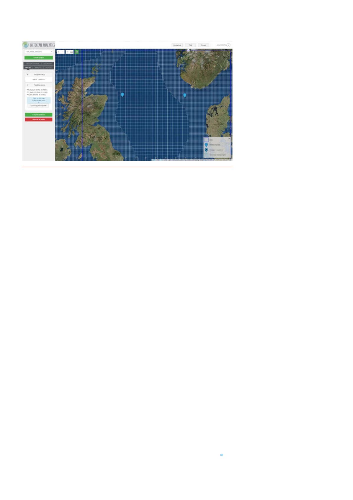
Figure 2.
Wave numerical simulation spatial grid for theNorth Sea. The spatial resolution is increased in
areas closer to the coast. Thiswave numerical simulation output is visualisedandanalysedwith thewith
Metocean Analytics solution.


