58 |
Oilfield Technology
June
2016
Offshore development presents challenges not only in
terms of production and worker security but also in terms of
environmental protection.
Theneedformetoceanknowledge
A thorough knowledge of the environmental conditions on site is
key. This includes sealife along with physical conditions such as
wind, wave and ocean currents. This is where the oceanography
comes into play in order to fill in the information about the
metocean conditions. Metocean analysis, metocean being the
contraction of meteorology and oceanography, covers all of
the necessary information for the development of any offshore
project.
Metocean analysis is important because the ocean covers
72% of the Earth’s surface and is difficult to monitor because of
its vast surface area and its depth of up to 4000 m over most of
its surface.
Livemonitoringandforecasting
Studying the ocean is challenging, not only because of its
vastness but also because of its temporal variability. Live
monitoring and forecasting of metocean conditions are thus
absolutely necessary to manage operations securely.
With the emergence of autonomous gliders, drifting
and profiling floats, combined with wind, wave and current
measuring buoys, and geostationary satellites, real time
knowledge of ocean conditions has greatly improved. And the
innovation of in-situ measurements is still very active as floating
Lidars are increasingly recognised as measurements of wind
profile.
Wind, and wave forecasting can accurately predict conditions
for upcoming days, helping to deal with emergency situations
associated with squalls or hurricanes for instance. However,
plenty of research work still needs to be done to go beyond a
week of forecasting. These two fields go hand in hand as waves
are generated directly by the wind.
On the other hand, even though ocean current forecasting
has shown some real improvement in the past 10 years, it still
lacks accuracy outside of regions dominated by tides. This is
still a pressing issue in a region like the Gulf of Mexico where the
Loop Current presents a spatial and temporal variability that is
difficult to understand and thus difficult to forecast. In 2015 for
instance, the Loop Current northern limit remained for a long
time period at a higher latitude than ever before for unexplained
reasons.
The challenge of ocean current forecasting lies in the
three dimensional dynamics of the fluid that cannot be easily
monitored over a large area, unlike the atmosphere, which
is now fully covered by satellite sensors. Monitoring and
building up records of historical conditions is thus essential for
improvements to ocean current forecasting.
Historicalmetoceanconditions
Hence, before thinking about live monitoring and forecasting, a
solid knowledge of historical conditions of metocean data on site
is essential.
Focusing on the development phase of any offshore project,
average metocean conditions are necessary but extreme
conditions are also needed for structure design that will resist
the rough offshore conditions, thus ensuring the longevity of the
FPSO or platform, and the safety of the people working on it.
In order to learn about historical conditions, in-situ
instruments have been the favoured choice, but the instruments
are required to be set up at sea and parameters are measured at
a single location, only for as long as they are left at sea.
In the North Sea and the Gulf of Mexico, offshore
developments have been going on for decades, thus offering
quite a large amount of measurements at numerous locations
providing valuable long term information. For any new
offshore locations outside of these two regions, long in-situ
measurements are quite scarce.
Satellite technology can be of great use to complete in-situ
measurements. Since the 1970s, several satellites have been
launched to measure sea surface temperature. Near surface
wind speed has been measured from scatterometer sensors with
interesting accuracy since the 1990s. More recently, sea surface
salinity has also been measured but with less accuracy than
sea surface temperature so far. Since the 1990s and the launch
of the Topex/Poseidon satellite,
altimetry sensors collecting sea
surface elevation data have been able
to provide valuable information about
waves.
However, the orbiting satellites
only cover a given location after a few
days, hence limiting the knowledge
about sub-daily temporal variability.
Therefore, even though direct
in-situ measurements and remote
sensing have greatly improved
over recent decades to provide key
information about ocean conditions,
they still present some limitations
when a more detailed knowledge
of historical metocean conditions
is necessary in more remote
locations, including the ‘new frontier’
regions such as Eastern Africa, or
South East Asia.
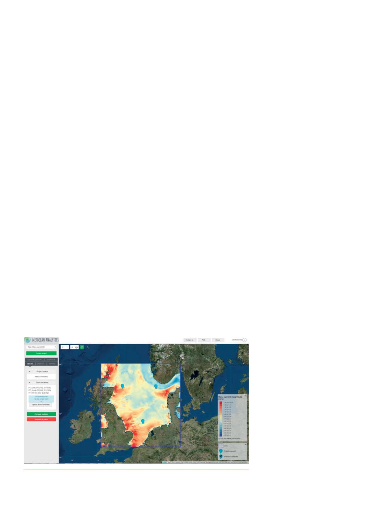
Figure 1.
Map ofmean ocean currentmagnitude over theNorth Seaproduced froman ocean current
numerical simulation output and visualisedwithMetocean Analytics.


