Throughout the pipeline route, it is vital to have accurate
assessments of near-bed currents (cross currents can impose
major loading) and sediment stability; knowledge of extreme or
ambient near-bed temperatures is also key. At each landfall it is
prudent to measure waves, water level and currents. Knowledge
of these aspects is vital to help clients and their engineering
contractor, in the design of the route and in deciding whether
the pipe needs to be buried or left exposed on the seabed.
In increasingly deep and constantly moving water columns,
sensors can assess the stress that currents will impose on pipes
later in the process and that may lead to scouring. Instruments
can measure current speed and direction at a single point in
the water or through use of Doppler technology they can
measure current profile through the full water column. In deep
water the seabed levels can vary dramatically, so knowledge
of current changes due to sudden drop offs is invaluable.
Reducing risk and uncertainty at this stage not only saves
money and time in the long-term but also increases safety
levels.
To record the vital data, sensors are placed on the seabed
at relevant water depths along the route. They are left in place
for a pre-determined period of time and typically comprise
single point current meters near the seabed that also measure
turbidity, temperature and pressure or current profilers near
features such as canyons or seamounts to study current
variability in those areas.
Moving to nearshore and landfall the designer has just as
many challenges. Breaking waves, for example, are usually a
signal that the pipe needs to be buried to protect its integrity.
Detailed metocean information is needed on topics including:
)
)
Extreme high and low water levels.
)
)
Extreme nearshore wave conditions along the shore
approach at the landfalls.
)
)
Extreme currents along the shore approach.
)
)
Assessment of near-bed-induced velocities with increasing
water depth.
)
)
Assessment of shore stability in nearshore region.
Every season has its own characteristics so a full 12 months
is recommended for sensors to acquire all the necessary
information, particularly in areas where extreme conditions
such as monsoons, cyclones, etc. are prevalent. This can
also help determine the most advantageous time of year for
pipelay. Fugro can also help to choose the right vessel (even
the direction of travel of the vessel can ensure smoother
operations with the minimum possible downtime).
During pipelay, sensors are vital
Once pipelay is underway both metocean and structural
monitoring sensors, and the experts who analyse the real time
data, play an invaluable role.
Current, wave and wind sensors on the pipelay vessel
provide real time data, which are communicated to the
engineers on board to help calculate the stress that the pipe
is withstanding during pipelay. Winds and vertical current
profiles may impose lay stresses greater than any stresses
designed for when the pipeline is in situ, so data at this time
are vital. A remotely operated vehicle (ROV) system on the
following vessel will enable the team to see what is going on;
it is equipped with a sensor to detect current activity, which is
communicated in real time.
A wave buoy alongside the pipeline route, or a wave
radar mounted onboard the slow moving vessel, provide
information on the exact conditions via a set of sensors.
Real-time metocean data are displayed onboard the vessel
and transferred in real time to the Fugro office where they
can be plotted against the forecast information to increase
confidence. The data are also used to calibrate model data
thereby improving forecast accuracy.
Structural monitoring sensors are also utilised during
pipelay operations. Accurate vessel motion data are used to aid
the assessment of weld quality, which is essential for safe and
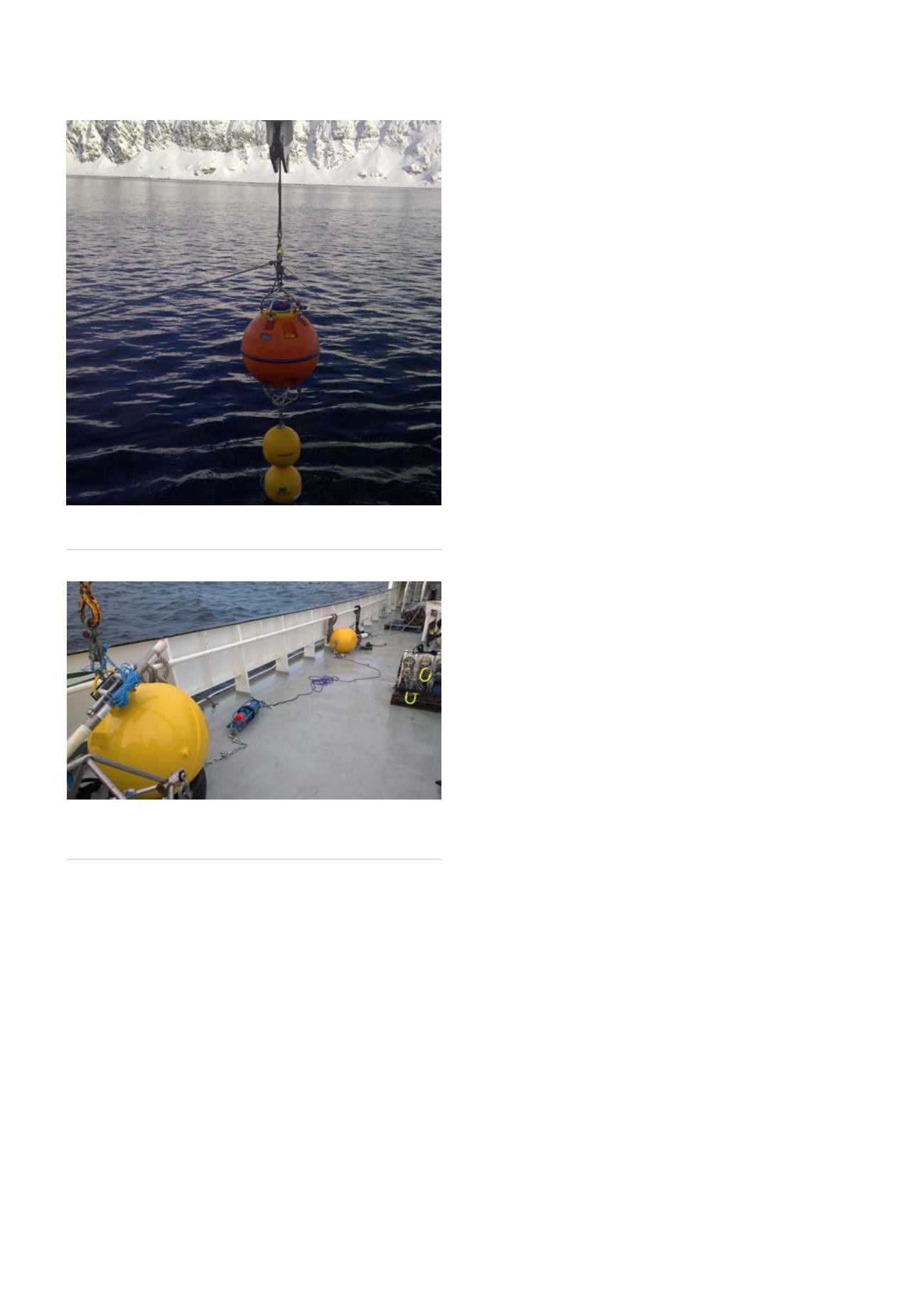
Figure 1.
ADCP mooring shows a current profiler instrument in
a subsurface float being deployed in northern Norway.
Figure 2.
Mooring on deck prior to deployment. Sensors
measure current speed and direction at a single point in the
water along with pressure, water temperature and turbidity.
86
World Pipelines
/
MARCH 2016


