May 2016
Oilfield Technology
|
59
lw d/mwd Q&A
Mark Norris,
Peter Cruickshank,
Austin Pile and
Marc Willerth,
Scientific Drilling
International, USA.
Directional drilling
Directional drilling is, at its core, a method of controlling
the direction of a wellbore to a predetermined target.
Whether the desired result is the retrieval of hydrocarbons,
geothermal energy or access from one point to another,
directional drilling is successful when the final position of the
wellbore is placed within that target. The extent to which this
success can be determined is limited by the accuracy of the
survey programme used to locate the bottom-hole location.
The need to accurately place a wellbore must be weighed
against the time required to survey since time drilling a well
translates directly to dollars spent.
Standard MWD survey practices rely on measurements at a
fixed interval (typically 95 ft +/-) with the assumption that the
well follows a perfect circular arc in between measurements.
Any deviations from this ‘smooth curve’ have the potential
to cause positional errors. The use of bent housing motors to
‘steer’ a wellbore can exaggerate this issue, by adding sharp
curves to the wellpath that are much shorter than 95 ft in
length. More frequent surveying can minimise these errors,
however the additional time required is an undesirable cost in
today’s market.
Scientific Drilling has addressed this quandary by creating
an approach whereby additional surveys are captured
without any additional rig time or equipment requirements.
Doubleshot combines these additional surveys with the
‘standard’ survey stations to improve the definitive position
of the wellbore.
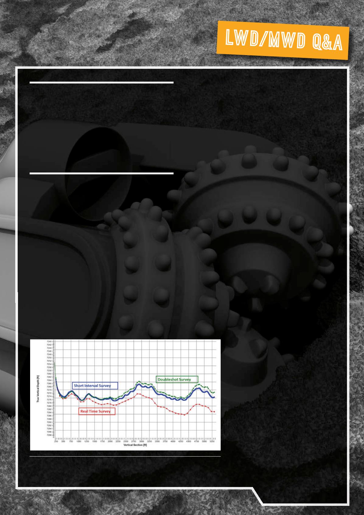
Studies in the DJ Basin found that two independent,
equally valid, surveys using 95 ft intervals can have over
25 ft of true vertical depth discrepancy at total depth. Using
shorter intervals, this reconciled to less than 6 ft of difference.
Continuous MWD measurements were used to validate that
the shorter interval was enough. This method not only lowers
the uncertainty around wellbore position, but also assists in
explaining geo-steering discrepancies between offset wells.
Removing TVD errors has significant benefits to geology
without incurring the expense of running additional LWD
tools. Offering no rig time implications, increased certainty of
wellbore position and immediate presentation on location,
Scientific Drilling is committed to offering solutions to
complex drilling challenges.
Drillingmechanics
Wellbore collision avoidance and accurate wellbore placement
are the primary concerns on multiwell onshore pads or offshore
platforms. Typically, up to 12 wells can be accommodated in
a single location with as little as 5 ft separation at surface.
Drilling the surface holes in these densely populated locations
with MWD tools that use magnetic measurements poses
significant risk due the magnetic interference exhibited
by the casing of the offset wellbores. In many cases, these
environments adversely affect the validity of the directional
measurements, violating collision avoidance rules and
generating uncertainty in wellbore placement.
Historically, gyroscopic measurements
obtained from wireline tools have been used
in the place of the MWD tools until the area
of magnetic interference has been cleared. At
each survey station, it is necessary to rig up
the wireline equipment and seat in a UBHO
positioned in the BHA, far behind the magnetic
MWD tools. The time taken to acquire a survey,
as well as the additional equipment required
on location, are an inconvenience in today’s
competitive marketplace.
The gyroMWD systems incorporate a
field-proven North seeking gyroscopic sensor
and magnetic sensors into a single MWD tool
or MWD collar. The result is a system that
provides gyroscopic measurements closer to
the bit, in less time, with less equipment than
a traditional gyro singleshot.
Figure 1.
Real time surveys at 95 ft spacing showa large shift fromshort interval surveys.
WithDoubleshot this discrepancy is resolved.


